
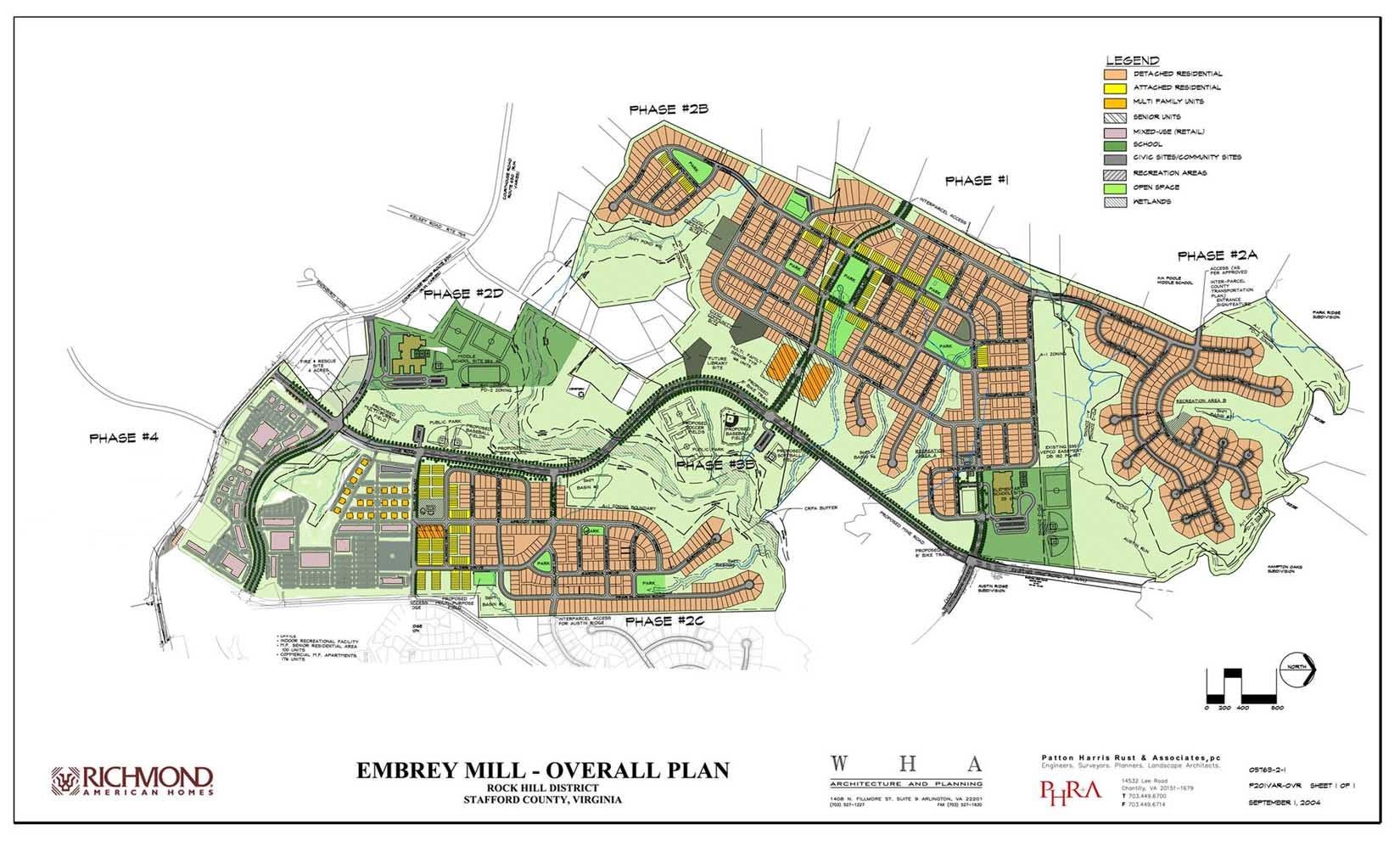
Embrey Mill Location: Stafford County, Virginia
Status: Under Construction: 95% residential, 50% commercial finished. Summary: The site consists of ~1000 acres, 40 miles south of Washington D.C., at interstate 95 and route 630 in Stafford county, Virginia. Stafford County is rural and does not presently have a walkable town center – only crossroads – 1 miles east on Rt. 630. This project provides an identifiable center for the county. The lower half of the site on Rt. 630 was master planned for high-density commercial and residential development. The site consists of hilly farmland, composed of two high, relatively level plateaus separated by a valley. A commuter parking lot, for express bus services to metro hub, is currently located across Rt. 630 from the future community and will be incorporated into the regional shopping district, also connected by shuttle. Three miles east on Rt. 630 is the Brooke commuter/heavy rail station connected by bus/shuttle. The demographics of the site indicated that there would be – 1/3 retirees, 1/3 commuters to Washington D.C., and 1/3 local. Special Features: We developed a program of walkable neighborhoods with an integration of uses, a variety of housing types (and costs) and lot sizes – including a regional shopping district, corner store, live/ work units, recreation centers, civic sites, and 2082 residential units.

We developed new urban and architectural codes for the Community since the County would not allow this project based on existing zoning codes. A code PD-2, based on our code for this community, was adopted by Stafford County, Virginia in 1990. Properties in Stafford County can now be rezoned PD-2, including smaller lots and set backs for integration of uses. The community plan is influenced by southern planning elements from Fredericksburg, Richmond, and Savannah, Georgia. The structure includes central-north/ south – grand Boulevards, as well as smaller scaled neighborhood streets (east-west) and a main street.
The community plan is composed of three walkable neighborhood clusters set on high plateaus. Each neighborhood has a center with squares, public buildings, shops, work places, childcare facilities and meeting hall accessible to the residents by a walk of approximately 10 minutes or less. The community is structured along a spine of public squares which form a park network that one can walk a long throughout each neighborhood and the community, encouraging walking rather than driving.

Site Information: Developer proffers: Single Family Detached Housing Units 1291 Multifamily Units (Walk-Ups) 301 Retail, Commercial and Office Space (SF) 1,400,000 Commercial Apartments 176 Single Family Attached Units 314 Total 2082 Units Community elements: 5 Out Door Recreation Facility Sites, 1 Indoor Recreation Site, 1 Elementary School, 2 Religious Sites, 3 Childcare Facility Sites, 1 Library Site, 3 Meeting Room Sites, Water Tower Landmark.